
|
|
|
|
CONTACT
FLOOD HISTORY
PHOTO GALLERY
SYSTEM COMPONENTS :
FORECASTS:
PROJECT
SYSTEM COMPONENTS
OPERATIONS
FORECASTS
|

EARLY WARNING
 FLOOD MONITORING NETWORK
The Flood Operations Center is the heart of the monitoring network.
The network is an integrated system of:
• Computerized river/stream telemetry
• Pumping station telemetry
• Satellite reception of weather and river forecast data
• Hurricane tracking
• River Ice observation and reporting
• Field monitoring by personnel
The network provides system operators with reliable real-time information to assist with critical operational decisions during an emergency.
The Operations Center, a self-sufficient center, has been designed to ensure network stability while providing system operators with uninterrupted communications and the timely dissemination of collected data.
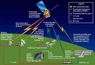 GOES SATELLITE PROGRAM
The Geostationary Operational Environmental Satellite Program (GOES) is a joint effort of NASA and the National Oceanic and Atmospheric Administration(NOAA). GOES is a complex system of weather satellites that provide critical and timely information to emergency management agencies - graphically displaying the intensity, path, and size of storms.
In 1999, the Sunbury Municipal Authority Flood Control department purchased the equipment to receive forecast data transmitted via the GOES network. Through the Emergency Managers Weather Information Network (EMWIN), GOES provides the Flood Control Department with an uninterrupted stream of nearly 40,000 pages of critical weather and river forecast data daily alerting of emerging severe weather patterns, storms and hurricane.
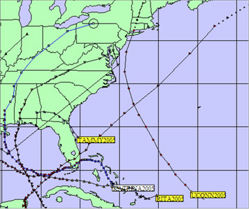 HURREVAC
HURREVAC stands for HURRicane EVACuation program. The program was developed for the US government in 1988 in response to a need for computer based management of data produced by various federal Hurricane Evacuation Studies. HURREVAC is designed to assist emergency managers in making decisions for communities under a hurricane threat.
HURREVAC tracks hurricanes on computer plot maps using information from the National Hurricane Center (National Weather Service, NOAA). Marine advisories on tropical storms are issued by the National Hurricane Center which contain information on present and forecast position, intensity, size, and movement. HURREVAC also estimates when various evacuation decisions should be made. HURREVAC is an essential forecast tool utilized by Operations Center personnel to monitor the path and intensity of an impending flood threat from a hurricane or tropical storm.
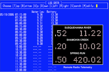 RIVER and STREAM TELEMETRY
The Operations Center is linked, via phone and wireless transmission, to three computerized telemetry stations located on Shamokin Creek, Spring Run and the Susquehanna River.
The telemetry stations provide 24-hour computerized monitoring of river and stream elevations. Elevation data is transmitted real-time to the Flood Operations Center.
Received data allows system operators to calculate exactly when to activate pumping stations, close hydraulic gates and install closures structures. The system also has the capability of contacting system operators during the evening and on weekends to warn of unexpected rises in river elevations and ice jams.
Flood Operations Center
826 Hillside Road
Sunbury, Pennsylvania 17801
All contents © 2015 Sunbury Municipal Authority | site design: BLH Media